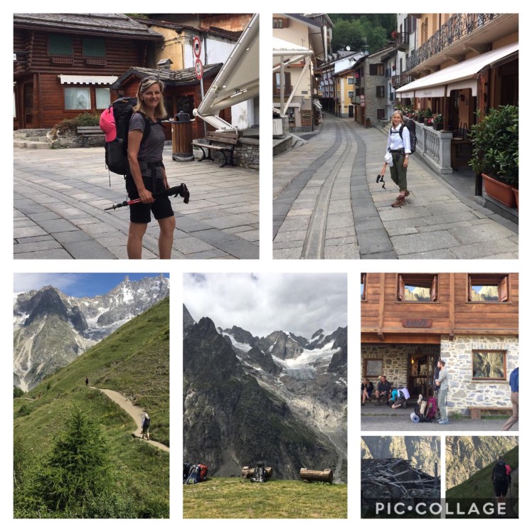
We did the hike in July of 2018 and as you will see from the pictures, we were very fortunate with the weather.
The authoritative reference book: “Tour of Mont Blanc” by Kev Reynolds:
https://books.google.ca/books/about/Tour_of_Mont_Blanc.html?id=8BXQ2GSlZL4C&redir_esc=y&hl=en
Official TMB Website:
http://www.autourdumontblanc.com/en/ – good for booking some refuges/huts
Airport transfers to and from Chamonix: by “Haute Transfer” cost €142
We suggest booking accommodations well in advance. We had some difficulties, but managed ok with booking Jan/Feb prior to early July trip. Would start booking accommodations one month earlier than we did. You are competing with tour companies for reservations. We recommend hiking it in early July. Mid to late June hikers had more rain and cloudy weather. We had great conditions. With plenty of time to book and plan this was very doable.
We recommend going counter-clockwise if only because had we hiked clockwise we would have had to go down some ladders which climbed up and would have liked even less than going up.
July 1-3 – Chamonix
Booked: Hotel Pointe Isabelle very good 165, Avenue Michel Croz, Chamonix City Centre, Chamonix Mont-Blanc; +33 4 50 53 12 87 Ask for the hotel card, which gives you access to free transportation in all of the surrounding area, covered by local transit – covers as far as Les Houches and Argentiere, which was very handy at the front and back end of our hikes. Note: we could have used one more night here to deal with jet lag.

Day 1 – Les Houches to Les Contamines (FRA)
Distance: 16.0km
Time:6h 30min
Height Gain:1479m
Height Loss:1264m
Max Elevation:1673m
Booked: Les Chalets des Contamines FFCAM good (Federation Francaise des Clubs Alpins et de Montagne) 22 Route du Plan Du Moulin Alpes, Mont-Blanc; tel from abroad: +33 (0)4 50 47 00 88 (for us: 04 50 47 00 88) Use hotel card to take free bus to Les Houches. We found the wooden stairs start of the trail and resisted the temptation of taking the telepherique (cable car) up to Belleview to start our hike.

Day 2 – Les Contamines to Croix du Bonhomme (FRA)
Distance:13.5km
Time:6h 30min
Height Gain:1509m
Height Loss:234m
Max Elevation:2481
Booked: Refuge de la Croix du Bonhomme From abroad: +33 (0)4 79 07 05 28; for us: 04 79 07 05 28
Would not stay here again, but it’s ok. Nice people. Kev Reynolds’ book recommends itinerary of Les Contamines to Les Chapieux. We recommend this. To secure a hotel room in Les Chapieux we strongly recommend booking by November/December of the year before. We could not get a room in January.

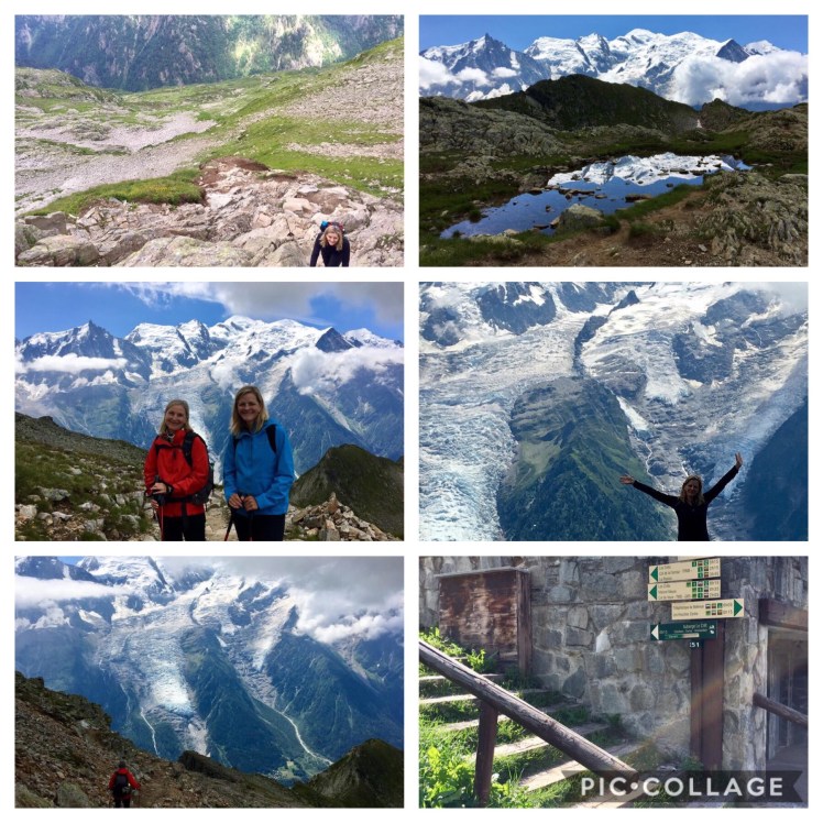
Day 3 – Croix du Bonhomme (FRA) to Rifugio Elisabetta (IT) (via Les Chapieux & Col de la Seigne)
Distance: 21.2km
Time: 7h 45min
Height Gain:1139m
Height Loss:1402m
Max Elevation: 2511m
Booked: Rifugio Elisabetta +39 0165 84 4080 very good hut
 The legs are working now
Day 4 – Rifugio Elisabetta to Courmayeur (IT)
Distance:16.1km
Time: 6h30min
Height Gain: 554m
Height Loss: 1544m
Max Elevation: 2419m
Booked: Hotel Cresta Et Duc +39 0165 842 585 fantastic


Day 5 – Courmayeur to Rifugio Bonatti (IT)
Distance:12.3km
Time: 5h 15min
Height Gain:1288m
Height Loss: 476m
Max Elevation: 2039m
Booked: Rifugio Bonatti +39 0165 185 5523 fantastic – book early; in high demand and no other options
 … and waaay back up again to the wonderful Rifugio Bonatti
Day 6 – Rifugio Bonatti (IT) to La Fouly via Grand Col Ferret (CH)
Distance: 21.5km
Time: 7h 30min
Height Gain: 1328m
Height Loss: 1745m
Max Elevation: 2531m
Booked: l’Hôtel du Col de Fenêtre à Ferret; La Fouly, 1944 Orsières +41 27 783 1188 this hotel is in the village of Ferret – only a short distance outside of La Fouly (you will hike through it first – ca 1-1.5 kms outside of La Fouly). It serves the best food in the entire area.

Distance:14.7km
Time: 4h 30min
Height Gain: 671m
Height Loss: 799m
Max Elevation: 1606m
Booked: Hotel Splendide; Fantasic – best hotel on the tour. Rue du Signal, Champex-Lac, 1938; +41 27 783 1145

Day 8 – Champex Lac to Trient (CH)
Distance: 15.5km
Time: 5h 15min
Height Gain: 914m
Height Loss: 1105m
Max Elevation: 2040m
Booked: Auberge du Montblanc Tel. +41 27 722 4623; good hostel; possible to get a private room with clean sheets and towels if you book in good time.

Day 9 – Trient (CH) to Tre le Champ (FRA) – via Col de Balme and Aiguille des Posettes
Distance: 13km
Time: 5h30m
Height Gain: 1069m
Height Loss: 1178m
Max Elevation:
Booked Le Dahu; very good 325 Rue Charlet Straton, Argentiere; +33 (0)4 50 54 01 55 We walked from Tre le Champ to Argentiere to our hotel, but in the morning we took a bus to Montroc and found our way back to the trail at Tre le Champ from there. When you get off at the Montroc bus station, cross the street and walk back down to a little side street, which will ultimately take you back to the Tre le Champ trail. Bus is free with hotel card (described above).
 Another solid climb
Day 10 – Tre le Champ to Plan Praz (FRA)
Distance: variation from Kevin Reynolds’ book – 20.0km
Time: 5h30min;
Height Gain: 1021m
Height Loss: 733m
Max Elevation: 2490m
Booked: Hotel Pointe Isabelle -165, Avenue Michel Croz, Chamonix City Centre, Chamonix Mont-Blanc; +33 4 50 53 12 87
This worked out well – it adds hiking time – almost 2.5 hours of time to the suggestion by Kev Reynolds (he suggests Tre le Champ to La Flegere) but we saw the refuge at La Flegere and would not have wanted to stay there. At Plan Praz there is a telepherique which you can take down into Chamonix. Sleep in Chamonix (maybe the same hotel you started at and left your suitcases at?) then do your last day of hiking with minimal backpack. We took the telepherique back up to Plan Praz for the last leg of the hike to Les Houches.

Day 11 – Plan Praz to Les Houches (FRA) (via la Brévent)
Distance:16 km
Time:6h 30min
Height Gain: 646m
Height Loss: 633m
Max Elevation: 1673m
Booked: for July 12-15 – Hotel Pointe Isabelle, as above
Notes:
Re the need for a rest day – Most people build in a rest day and it is strongly recommended. We did not do that and we were fine with this itinerary. Day 7 is very light compared to the rest of the days and that was our rest day. Most people rest in Courmayeur. If you have time for a rest day, we would recommend resting at the Hotel Splendide in La Fouly, just because of how awesome this place is. We were lucky in that we had great weather. A rest day might have been a saving grace had we had challenging weather.
Packing List:
We found we had overpacked a bit. We were able to can wash every day. Good, thin, dry-fit layers do dry quickly. Even the merino hiking socks dried each night. We used a 38 liter pack; this should have a rain cover.
• Use packing cubes – really kept our stuff organized and from spilling out all over every time you need something – we used 3 each, which includes one for toiletries; this was very handy when going for a shower, when you could take a cube with all you need. In hindsight, we would pack:
• rain jacket
• rain pants
• thin fleece
• light weight, long-sleeved merino top
• dry fit short sleeved top
• light but wind-resistant gloves (good forhigh altitudes)
• 1 hiking shirts/blouses with UV protection and/or 1 dry fit T-shirts (whichever you prefer – don’t take all 4 – pick your favourites)
• 1 pair of hiking pants – zip off legs if you like shorts
• 2 pairs hiking socks and liners
• 2 pairs of dry fit underpants
• 21sports bra
• t-shirt & leggings for lounging – these can double up as PJs w
• eye/sleep mask to block out light
• ear plugs
• Camp Suds by Coleman – biodegradable; don’t bring whole bottle; a little goes a long way; will wash your hair (for refuge days where there is no shampoo) and clothes
• conditioner – most hotels have shampoo – no place at all had conditioner
• usual toiletries – keep it light; no need for make up; you will sweat it off immediately; we did not each carry creams, etc., rather shared and divided the carrying between us
• headlight if you want (recommended but we used our phone flashlight – so I would not take again)
• converter plug and chargers for phone, etc.
• foot care stuff – some blister Bandaids, etc.
• Body Glide (sold at running stores and any place that sells neoprene suits for diving/swimming); use this for foot lubrication; we had very few if any foot problems with body glide and liner socks – we also lubricated ankles generously to prevent hiker’s rash.
• sunblock – at least SPF 50; we went through 2 x 75 ml. tubes with 2 people
• hiking poles
• brimmed sunhat
• sunglasses
• hiking boots
• 1 water bottle (we found opportunities to refill along the route each day)
• sleeping bag liner – we recommend silk (we found very affordable liner online)
• two light-weight absorbent towels; keep them small – it will do
• we don’t recall eating power bars
• rehydration tablets (i.e. Nuun) for your water – this really made a huge difference
• essential: Advil – an anti-inflammatory; this saved us on a couple of occasions when toes were sore from long descents and when one of us hiked being sick – masked pain and got us through
• small Swiss Army knife – scissors on the knife are really handy; great for cutting up foot care stuff, cheese, etc. – don’t put in carry-on, it will be taken away
• luxury item: very light-weight mesh-like sneakers for wearing out to dinner when in a town – you will really, really want to get those boots off
• very light flip flops – great for showers in huts
Would try to keep weight at 20 lbs or less.
Accommodations at refuges: they all offer demi-pension: breakfast and dinner; most offer a picnic for your next day’s lunch; these were not great in quality but ok. Eventually we got sick of them and quit ordering them, rather when in a town bought a baguette, some Savoie sausage (sorry veggie friends), cheese and fruit to make our own picnic. All huts had wifi and charging stations.
Other:
We trained and were very grateful to arrive fit.
Most refuges like a call ahead to confirm your arrival a day or so before. The refuge where you stayed the night before will sometimes do that for you if you ask them to. Refuges are a great place to meet people and nowhere near as noisy for sleeping as people say. We had zero snoring or farting fiascos. We enjoyed the social part of the trip very much and no, the trail was not too crowded. It was just fine. Try to arrive at refuges early to get a good hot water supply for your shower and first dibs at beds.
Enjoy!
Katja & Florence
